Absolute garbage... 30cm+ for Tofino?PortKells wrote: ↑Wed Feb 28, 2024 9:35 pm It's kinda weird right now, the euro keeps tripling down on a decent sized snowfall on Friday, but the HRDPS, NAM etc. aren't showing much of anything. I don't count the GFS it has a history of donking out in these situations...however the fact the Euro is with it is very interesting. Seems unlikely but maybe its sniffing something out?
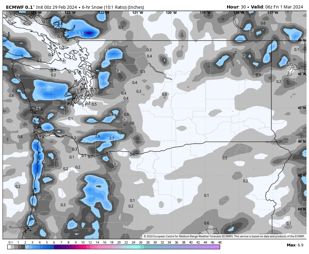
ecmwf-deterministic-vancouverski-total_snow_kuchera_cm-9467200.png
February 2024 Forecasts and Discussions
-
Typeing3
- Weather Psycho

- Posts: 13165
- Joined: Sun Feb 17, 2019 3:02 pm
- Location: Coquitlam
- Elevation: 25M./80Ft.
- Has thanked: 23854 times
- Been thanked: 25720 times
Re: February 2024 Forecasts and Discussions
East Coquitlam
Elevation 25M (80Ft)
#MrJanuary
-
PortKells
- Storm Chaser

- Posts: 7119
- Joined: Sun Feb 17, 2019 4:08 pm
- Location: Port Kells
- Elevation: 78m
- Has thanked: 576 times
- Been thanked: 12509 times
Re: February 2024 Forecasts and Discussions
Ok, OBVIOUSLY you shouldn't take the exact amounts from that map as much as the general message its selling that there will be a snowfall at all, probably one that can produce up to 10cm in spots. Which is in contrast with the other models (other than the GFS)
-
PortKells
- Storm Chaser
- Posts: 7119
- Joined: Sun Feb 17, 2019 4:08 pm
- Location: Port Kells
- Elevation: 78m
- Has thanked: 576 times
- Been thanked: 12509 times
Re: February 2024 Forecasts and Discussions
It's the top performing model, I figured people might be interested in seeing it.
-
wetcoast91

- Storm Chaser
- Posts: 6618
- Joined: Sun Feb 17, 2019 3:12 pm
- Location: New Westminster
- Elevation: 106m
- Has thanked: 6529 times
- Been thanked: 15249 times
 maps.
maps.
-
wetcoast91
- Storm Chaser
- Posts: 6618
- Joined: Sun Feb 17, 2019 3:12 pm
- Location: New Westminster
- Elevation: 106m
- Has thanked: 6529 times
- Been thanked: 15249 times
-
SouthSardiswx

- Donator

- Posts: 20946
- Joined: Sun Feb 17, 2019 2:37 pm
- Location: Chilliwack (South Sardis)
- Has thanked: 55853 times
- Been thanked: 18140 times
Re: February 2024 Forecasts and Discussions
The main theme of snow potential resonates with me Kells.
Join us next season for the 8th annual that's not accurate snowfall contest.
 Wrinkle Rockers: 15.0cm

 South Sardinies: 3.5cm
CYCW station
https://cycw.awos.live/local-weather
CYCW station
https://cycw.awos.live/local-weather
-
Weather101

- Storm Chaser
- Posts: 5369
- Joined: Fri Feb 22, 2019 7:27 am
- Location: Richmond
- Elevation: 3 Ft
- Has thanked: 5025 times
- Been thanked: 7544 times
Re: February 2024 Forecasts and Discussions
VanCitySouth wrote: ↑Wed Feb 28, 2024 8:16 pm On an interesting note, wicked cold front out east. Ottawa from +16 to -13 in 8 hours.
You do not have the required permissions to view the files attached to this post.
All about them Cowboys !!! 

-
PortKells
- Storm Chaser
- Posts: 7119
- Joined: Sun Feb 17, 2019 4:08 pm
- Location: Port Kells
- Elevation: 78m
- Has thanked: 576 times
- Been thanked: 12509 times
Re: February 2024 Forecasts and Discussions
There does seem to be potential;
You do not have the required permissions to view the files attached to this post.
-
Storm

- Storm Chaser
- Posts: 7020
- Joined: Sun Feb 17, 2019 2:09 pm
- Location: North Burnaby/Burquitlam
- Has thanked: 2489 times
- Been thanked: 12401 times
Re: February 2024 Forecasts and Discussions
925mb is taking a beating.
You do not have the required permissions to view the files attached to this post.
North Burnaby/Burquitlam
Elevation - 64 M./210 Feet
Elevation - 64 M./210 Feet
-
tyweather

- Model Rider

- Posts: 1669
- Joined: Sun Feb 17, 2019 2:39 pm
- Location: Newton, Surrey, EL. 70m
- Has thanked: 73 times
- Been thanked: 3801 times
Re: February 2024 Forecasts and Discussions
Back to snow on Cypress. 5 cm so far.
Why not try cycling to work, grocery store, anywhere!
-
Rubus_Leucodermis

- Storm Chaser
- Posts: 5689
- Joined: Thu Nov 21, 2019 5:48 pm
- Location: Vancouver
- Elevation: 70 m / 230 ft
- Has thanked: 4627 times
- Been thanked: 11581 times
Re: February 2024 Forecasts and Discussions
Its limited resolution gives it real issues with terrain bleed in our locale. If no high res short term model shows anything in the lowlands, I say throw it out.
Remember, the Euro called for a big dump Tuesday night. NAM 3km said a few slushy cm. Which was right?
It's called clown range for a reason.
-
wetcoast91
- Storm Chaser
- Posts: 6618
- Joined: Sun Feb 17, 2019 3:12 pm
- Location: New Westminster
- Elevation: 106m
- Has thanked: 6529 times
- Been thanked: 15249 times
Re: February 2024 Forecasts and Discussions
I actually think the Euro will verify in that the coastal regions will be impacted most. The coldest air aloft and heaviest showers will remain near the coast.Rubus_Leucodermis wrote: ↑Thu Feb 29, 2024 7:12 am Its limited resolution gives it real issues with terrain bleed in our locale. If no high res short term model shows anything in the lowlands, I say throw it out.
Remember, the Euro called for a big dump Tuesday night. NAM 3km said a few slushy cm. Which was right?
-
Hawk

- Storm Chaser
- Posts: 7561
- Joined: Mon Feb 18, 2019 6:45 pm
- Location: Langley/The Similkameeeens
- Elevation: 320ft/3000ft
- Has thanked: 14320 times
- Been thanked: 7216 times
Re: February 2024 Forecasts and Discussions
Look at that instability..whoa 
So Nito is saying the high hills of Westside Van will score? I remember once way back..forecast similar to this one. Low formed in the unstable airmass...and stalled near Victoria..dumped about 30cms in Kerrisdale. Must have been around 2000. Amazing HUGE fluffy flakes for hours
So Nito is saying the high hills of Westside Van will score? I remember once way back..forecast similar to this one. Low formed in the unstable airmass...and stalled near Victoria..dumped about 30cms in Kerrisdale. Must have been around 2000. Amazing HUGE fluffy flakes for hours
April is here and the weather only gets better now 
Willoughby Langley at ~320ft / Similkameeeens ~3400ft
Willoughby Langley at ~320ft / Similkameeeens ~3400ft
-
Hawk
- Storm Chaser
- Posts: 7561
- Joined: Mon Feb 18, 2019 6:45 pm
- Location: Langley/The Similkameeeens
- Elevation: 320ft/3000ft
- Has thanked: 14320 times
- Been thanked: 7216 times
Re: February 2024 Forecasts and Discussions
Sounds like Nito is going for 5 to 10cms in localized areas due to some powerful instability
#teamNito
April is here and the weather only gets better now
Willoughby Langley at ~320ft / Similkameeeens ~3400ft
Willoughby Langley at ~320ft / Similkameeeens ~3400ft
-
PortKells
- Storm Chaser
- Posts: 7119
- Joined: Sun Feb 17, 2019 4:08 pm
- Location: Port Kells
- Elevation: 78m
- Has thanked: 576 times
- Been thanked: 12509 times
Re: February 2024 Forecasts and Discussions
You do not have the required permissions to view the files attached to this post.