January 2021 Forecasts and Discussions
- PortKells
- Storm Chaser

- Posts: 6607
- Joined: Sun Feb 17, 2019 4:08 pm
- Location: Port Kells
- Elevation: 78m
- Has thanked: 557 times
- Been thanked: 11449 times
Re: January 2021 Forecasts and Discussions
Retrogression signs in the long range. About time, we've been in the wilderness for a while now.
- Hawk
- Storm Chaser

- Posts: 6970
- Joined: Mon Feb 18, 2019 6:45 pm
- Location: Langley/The Similkameeeens
- Elevation: 320/3024
- Has thanked: 12700 times
- Been thanked: 6464 times
Re: January 2021 Forecasts and Discussions
Yes yesterday was an ugly day even all the way up here in the silkameen. The temp spiked up to about five or six and then we started getting some light rain in the afternoon and when I say light rain I mean very light rain. So that back-to-back melty kind of days up here. If we never had that massive snowfall on Dec21 it would be pretty much bare up here by now.
And here it is..December 2024 all snow geeks have been waiting for  ..with the LR weather "charts" calling for a cold and snowy month. Where's the troffing?

Willoughby Langley at ~320ft / Similkameeeens ~3400ft
Willoughby Langley at ~320ft / Similkameeeens ~3400ft
- PortKells
- Storm Chaser

- Posts: 6607
- Joined: Sun Feb 17, 2019 4:08 pm
- Location: Port Kells
- Elevation: 78m
- Has thanked: 557 times
- Been thanked: 11449 times
Re: January 2021 Forecasts and Discussions
What’s your elevation, just curious.Hawk wrote: ↑Sun Jan 03, 2021 7:17 am Yes yesterday was an ugly day even all the way up here in the silkameen. The temp spiked up to about five or six and then we started getting some light rain in the afternoon and when I say light rain I mean very light rain. So that back-to-back melty kind of days up here. If we never had that massive snowfall on Dec21 it would be pretty much bare up here by now.
- PortKells
- Storm Chaser

- Posts: 6607
- Joined: Sun Feb 17, 2019 4:08 pm
- Location: Port Kells
- Elevation: 78m
- Has thanked: 557 times
- Been thanked: 11449 times
- Catnip
- Moderator

- Posts: 9716
- Joined: Sun Feb 17, 2019 4:01 pm
- Location: Coquitlam (Mundy Park)
- Elevation: 530ft
- Has thanked: 11903 times
- Been thanked: 21488 times
Re: January 2021 Forecasts and Discussions
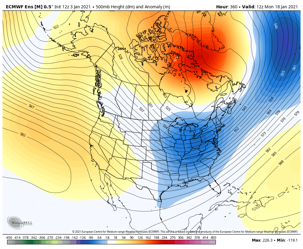
GFS is toying with the idea of wanting to dump a ton of cold air somewhere..... maybe east of the Rockies?
EPS not playing that game yet.
GEFS not quite there yet either.
*Maps are posted for discussion/entertainment purposes only, and not because I necessarily believe them to be true.


#teamsnow #surprises #beginningofFEB #FEB
2022-2023 Snowfall - 114.5cm
Wx Stn: https://tinyurl.com/yxervg27
#teamsnow #surprises #beginningofFEB #FEB
2022-2023 Snowfall - 114.5cm
Wx Stn: https://tinyurl.com/yxervg27
- PortKells
- Storm Chaser

- Posts: 6607
- Joined: Sun Feb 17, 2019 4:08 pm
- Location: Port Kells
- Elevation: 78m
- Has thanked: 557 times
- Been thanked: 11449 times
- Radar
- Weather Fanatic

- Posts: 807
- Joined: Sun Feb 17, 2019 7:23 pm
- Location: West Abbotsford
- Elevation: 290ft
- Has thanked: 33 times
- Been thanked: 1516 times
Re: January 2021 Forecasts and Discussions
My garlic is starting to grow nicely. Maybe early spring this year with some February 1st blossoms in 28 days. Should I start pruning trees soon? Probably a long spring full of rain this year.
West Abby. Elev. 290ft
PWS: https://www.wunderground.com/dashboard/pws/IABBOT57/
24/25 snow total: 0cm
PWS: https://www.wunderground.com/dashboard/pws/IABBOT57/
24/25 snow total: 0cm
- wetcoast91
- Storm Chaser

- Posts: 6165
- Joined: Sun Feb 17, 2019 3:12 pm
- Location: New Westminster
- Elevation: 106m
- Has thanked: 6129 times
- Been thanked: 14056 times
Re: January 2021 Forecasts and Discussions
I will let the American Forums put a positive spin on it...but the model runs appear to indicate a potential split flow by mid month with positive heights along the West Coast. Aleutian low still present and cold air lodged firmly in Siberia and not inching anywhere.


- AbbyJr
- Storm Chaser

- Posts: 5602
- Joined: Sun Feb 17, 2019 2:14 pm
- Location: Abbotsford
- Elevation: 50m(164ft)
- Has thanked: 10324 times
- Been thanked: 10091 times
Re: January 2021 Forecasts and Discussions
Way too much run to run variability to have any kind of confidence in any given solution. SSW still in progress so to be expected.wetcoast91 wrote: ↑Sun Jan 03, 2021 11:11 am I will let the American Forums put a positive spin on it...but the model runs appear to indicate a potential split flow by mid month with positive heights along the West Coast. Aleutian low still present and cold air lodged firmly in Siberia and not inching anywhere.

Central Abbotsford
50m (164ft)
2022/23 season snowfall: 76.8cm


50m (164ft)
2022/23 season snowfall: 76.8cm


- wetcoast91
- Storm Chaser

- Posts: 6165
- Joined: Sun Feb 17, 2019 3:12 pm
- Location: New Westminster
- Elevation: 106m
- Has thanked: 6129 times
- Been thanked: 14056 times
Re: January 2021 Forecasts and Discussions
Models have been consistent with cold air pooling in Siberia with a gradual retreat of the AK vortex to allow for development of positive heights along the West Coast. MJO in a phase 4/5 state appears to be indicative of this.
This could set Western NA up for cold sometime down the road as a blocky regime takes hold but this appears unlikely for the next 2-3 weeks. More likely we see ridging and split flow.
Most of us have been thinking of a colder than normal FMA period and this appears to be on track.
One thing is for sure. The CFS and ECMWF weeklies have been awful this winter. Both had the East torching and the West getting cold by mid Jan.

- Catnip
- Moderator

- Posts: 9716
- Joined: Sun Feb 17, 2019 4:01 pm
- Location: Coquitlam (Mundy Park)
- Elevation: 530ft
- Has thanked: 11903 times
- Been thanked: 21488 times
Re: January 2021 Forecasts and Discussions
#beginningofFEBwetcoast91 wrote: ↑Sun Jan 03, 2021 11:55 am Models have been consistent with cold air pooling in Siberia with a gradual retreat of the AK vortex to allow for development of positive heights along the West Coast. MJO in a phase 4/5 state appears to be indicative of this.
This could set Western NA up for cold sometime down the road as a blocky regime takes hold but this appears unlikely for the next 2-3 weeks. More likely we see ridging and split flow.
Most of us have been thinking of a colder than normal FMA period and this appears to be on track.
One thing is for sure. The CFS and ECMWF weeklies have been awful this winter. Both had the East torching and the West getting cold by mid Jan.
*Maps are posted for discussion/entertainment purposes only, and not because I necessarily believe them to be true.


#teamsnow #surprises #beginningofFEB #FEB
2022-2023 Snowfall - 114.5cm
Wx Stn: https://tinyurl.com/yxervg27
#teamsnow #surprises #beginningofFEB #FEB
2022-2023 Snowfall - 114.5cm
Wx Stn: https://tinyurl.com/yxervg27
- AbbyJr
- Storm Chaser

- Posts: 5602
- Joined: Sun Feb 17, 2019 2:14 pm
- Location: Abbotsford
- Elevation: 50m(164ft)
- Has thanked: 10324 times
- Been thanked: 10091 times
Re: January 2021 Forecasts and Discussions
Well with the run to run variability, I was referring to the GFS. Ensembles have been consistent, but given the ongoing SSW, I would not be surprised to see a sudden flip in the models to a more desirable solution.wetcoast91 wrote: ↑Sun Jan 03, 2021 11:55 am Models have been consistent with cold air pooling in Siberia with a gradual retreat of the AK vortex to allow for development of positive heights along the West Coast. MJO in a phase 4/5 state appears to be indicative of this.
This could set Western NA up for cold sometime down the road as a blocky regime takes hold but this appears unlikely for the next 2-3 weeks. More likely we see ridging and split flow.
Most of us have been thinking of a colder than normal FMA period and this appears to be on track.
One thing is for sure. The CFS and ECMWF weeklies have been awful this winter. Both had the East torching and the West getting cold by mid Jan.

We may have to wait until February but I like our chances for the last week of January. Maybe I'm too optimistic but what I see in the models seems very consistent with a Siberian SSW, which usually results in a big pattern flip 2-3 weeks after the warming event completes.
Models will take time to catch up to the SSW induced atmospheric shakeup. In the meantime, the model ride continues.
Central Abbotsford
50m (164ft)
2022/23 season snowfall: 76.8cm


50m (164ft)
2022/23 season snowfall: 76.8cm


-
Snowman
- Cloud Watcher

- Posts: 50
- Joined: Sat Nov 23, 2019 5:51 pm
- Location: Abbotsford
- Elevation: 70 M./ 225 Ft.
- Has thanked: 189 times
- Been thanked: 241 times
Re: January 2021 Forecasts and Discussions
I had about 30 cm of snow from December 21-31 at my location. It took two days of gusty south winds and showers and it's already all gone  . At least there is actually blue sky today! Currently 7 degrees.
- PortKells
- Storm Chaser

- Posts: 6607
- Joined: Sun Feb 17, 2019 4:08 pm
- Location: Port Kells
- Elevation: 78m
- Has thanked: 557 times
- Been thanked: 11449 times
Re: January 2021 Forecasts and Discussions
I used to live in west Kelowna. What part are you in? Lakeview always seemed to do well for snow.
- AbbyJr
- Storm Chaser

- Posts: 5602
- Joined: Sun Feb 17, 2019 2:14 pm
- Location: Abbotsford
- Elevation: 50m(164ft)
- Has thanked: 10324 times
- Been thanked: 10091 times
Re: January 2021 Forecasts and Discussions
Central Abbotsford
50m (164ft)
2022/23 season snowfall: 76.8cm


50m (164ft)
2022/23 season snowfall: 76.8cm


