Yea It’s possible
February 2021 Forecasts and Discussions
- Monty
- Weather Enthusiast

- Posts: 4477
- Joined: Sun Feb 17, 2019 2:56 pm
- Has thanked: 932 times
- Been thanked: 9249 times
Re: February 2021 Forecasts and Discussions
North end of Shawnigan Lake. Southern Vancouver island. 500ft
- Monty
- Weather Enthusiast

- Posts: 4477
- Joined: Sun Feb 17, 2019 2:56 pm
- Has thanked: 932 times
- Been thanked: 9249 times
Re: February 2021 Forecasts and Discussions
Doing better than I expected this morning. Looks like 4-5cm already.
EC is forecasting 15-20cm for the malahat. Or is it 20-30cm.
“ 4:43 AM PST Sunday 14 February 2021
Snowfall warning in effect for:
Malahat Highway - Goldstream to Mill Bay
A long period of snowfall with total amounts of 15 to 20 cm is expected.
A Pacific front will cross Vancouver Island today spreading snow over Vancouver Island. The snow is expected to become mixed with rain this evening as another system reaches the region. Snow at times mixed with rain will continue through Monday. Total snowfall amount of 20 to 30 cm is expected by Monday afternoon.â€Â
North end of Shawnigan Lake. Southern Vancouver island. 500ft
-
South Island
- Cloud Watcher

- Posts: 60
- Joined: Sun Feb 17, 2019 7:58 pm
- Location: Victoria
- Has thanked: 330 times
- Been thanked: 107 times
Re: February 2021 Forecasts and Discussions
We have about 2-3 cm of new snow in Victoria. Snowing nicely right now.
- Rubus_Leucodermis
- Storm Chaser

- Posts: 5321
- Joined: Thu Nov 21, 2019 5:48 pm
- Location: Vancouver
- Elevation: 70 m / 230 ft
- Has thanked: 4380 times
- Been thanked: 10686 times
Re: February 2021 Forecasts and Discussions
Looking at the latest Euro and GFS runs, up to 10 cm seems much more realistic for that area.
(And I would be lucky to get half that amount.)
It's called clown range for a reason.
- Storm
- Storm Chaser

- Posts: 6587
- Joined: Sun Feb 17, 2019 2:09 pm
- Location: North Burnaby/Burquitlam
- Has thanked: 2397 times
- Been thanked: 11313 times
Re: February 2021 Forecasts and Discussions
More snow for them after this hour.Rubus_Leucodermis wrote: ↑Sun Feb 14, 2021 8:09 am Looking at the latest Euro and GFS runs, up to 10 cm seems much more realistic for that area.
(And I would be lucky to get half that amount.)
You do not have the required permissions to view the files attached to this post.
North Burnaby/Burquitlam
Elevation - 64 M./210 Feet
Elevation - 64 M./210 Feet
- wetcoast91
- Storm Chaser

- Posts: 6215
- Joined: Sun Feb 17, 2019 3:12 pm
- Location: New Westminster
- Elevation: 106m
- Has thanked: 6165 times
- Been thanked: 14141 times
Re: February 2021 Forecasts and Discussions
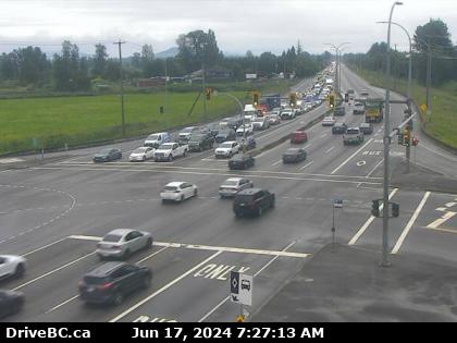
Live view of the banana belt.

Makes you wonder if there's a source of dry cold air that comes from Pitt Lake as there's snow just west in Coquitlam and in Haney.

Makes you wonder if there's a source of dry cold air that comes from Pitt Lake as there's snow just west in Coquitlam and in Haney.
- Monty
- Weather Enthusiast

- Posts: 4477
- Joined: Sun Feb 17, 2019 2:56 pm
- Has thanked: 932 times
- Been thanked: 9249 times
Re: February 2021 Forecasts and Discussions
We’ll see how long it takes to warm the east valley in this pattern. Could be awhileRubus_Leucodermis wrote: ↑Sun Feb 14, 2021 8:09 am Looking at the latest Euro and GFS runs, up to 10 cm seems much more realistic for that area.
(And I would be lucky to get half that amount.)
North end of Shawnigan Lake. Southern Vancouver island. 500ft
- Storm
- Storm Chaser

- Posts: 6587
- Joined: Sun Feb 17, 2019 2:09 pm
- Location: North Burnaby/Burquitlam
- Has thanked: 2397 times
- Been thanked: 11313 times
Re: February 2021 Forecasts and Discussions
They are going to get hammered.
You do not have the required permissions to view the files attached to this post.
North Burnaby/Burquitlam
Elevation - 64 M./210 Feet
Elevation - 64 M./210 Feet
- SunnyinLadner
- Casual Observer

- Posts: 25
- Joined: Mon Feb 18, 2019 1:49 pm
- Location: Ladner
- Elevation: Sea level
- Has thanked: 103 times
- Been thanked: 98 times
Re: February 2021 Forecasts and Discussions
Snowing lightly this morning, a fresh dusting everywhere
- Rubus_Leucodermis
- Storm Chaser

- Posts: 5321
- Joined: Thu Nov 21, 2019 5:48 pm
- Location: Vancouver
- Elevation: 70 m / 230 ft
- Has thanked: 4380 times
- Been thanked: 10686 times
Re: February 2021 Forecasts and Discussions
That still puts them more in the 15 cm range, not 25. And the Euro is significantly more stingy.
It's called clown range for a reason.
- Forrest Gump
- Weather Enthusiast

- Posts: 4471
- Joined: Sun Feb 17, 2019 3:11 pm
- Location: South Surrey/White Rock
- Elevation: 377 Ft. or 115 M
- Has thanked: 12477 times
- Been thanked: 8212 times
Re: February 2021 Forecasts and Discussions
It has started snowing here, probably for at least half hr.
- Abby_wx
- Moderator

- Posts: 1513
- Joined: Sun Feb 17, 2019 2:14 pm
- Location: Mission City
- Elevation: 157m (515ft)
- Has thanked: 6928 times
- Been thanked: 3940 times
Re: February 2021 Forecasts and Discussions
A few flakes flying here, but it looks like the bulk of it is going south once again.
Temp -0.6C, dew point -5.6C
Temp -0.6C, dew point -5.6C

Fall/Winter 2023/24
Low min: -16.6C (Jan 12th)
Low max: -9.9C (Jan 12th)
Snowfall: 8.0 cm
- Rubus_Leucodermis
- Storm Chaser

- Posts: 5321
- Joined: Thu Nov 21, 2019 5:48 pm
- Location: Vancouver
- Elevation: 70 m / 230 ft
- Has thanked: 4380 times
- Been thanked: 10686 times
Re: February 2021 Forecasts and Discussions
Looking at the 06z Euro and GFS runs, up to 10 cm for you in the next 24 hours seems quite likely. (GFS says you should see around 15 cm, Euro about half that.)
It's called clown range for a reason.
- VanCitySouth
- Weather Enthusiast

- Posts: 3757
- Joined: Sun Feb 17, 2019 2:21 pm
- Location: Vancouver (Langara)
- Elevation: 72 m/236 ft
- Has thanked: 4109 times
- Been thanked: 8003 times
Re: February 2021 Forecasts and Discussions
Happy Sunday! Pleasant surprise this morning. Light snow, 1 cm new.
2024-25 season stats:
Climo 0 to 0
  GFS
GFS
Season total: 1 trace (Teflon on Nov 18)
Climo
Season total: 1 trace (Teflon on Nov 18)
- wetcoast91
- Storm Chaser

- Posts: 6215
- Joined: Sun Feb 17, 2019 3:12 pm
- Location: New Westminster
- Elevation: 106m
- Has thanked: 6165 times
- Been thanked: 14141 times
Re: February 2021 Forecasts and Discussions
Was snowing here but now down to very flurries with filtered sunshine coming out. Can make the outline of the North Shore towards Coquitlam. RH at the surface doesn't seem dry but my guess is weak outflow aloft killing this next wave of moisture from entering too far Inland. Tomorrows system certainly looks more juicy.
