December 2020 Forecasts and Discussions
- AbbyJr
- Storm Chaser

- Posts: 5632
- Joined: Sun Feb 17, 2019 2:14 pm
- Location: Abbotsford
- Elevation: 50m(164ft)
- Has thanked: 10391 times
- Been thanked: 10148 times
Re: December 2020 Forecasts and Discussions
Central Abbotsford
50m (164ft)
2022/23 season snowfall: 76.8cm


50m (164ft)
2022/23 season snowfall: 76.8cm


- Catnip
- Moderator

- Posts: 9791
- Joined: Sun Feb 17, 2019 4:01 pm
- Location: Coquitlam (Mundy Park)
- Elevation: 530ft
- Has thanked: 11972 times
- Been thanked: 21631 times
Re: December 2020 Forecasts and Discussions
"How can you in good conscience charge money for this garbage? All you do is spit out models as your forecast. When they say cold, you say cold, and vice versa. This is not meteorology, which requires some skill past just reporting what the models show. Here’s this from yesterday!"
*Maps are posted for discussion/entertainment purposes only, and not because I necessarily believe them to be true.


#teamsnow #surprises #beginningofFEB #FEB
2022-2023 Snowfall - 114.5cm
Wx Stn: https://tinyurl.com/yxervg27
#teamsnow #surprises #beginningofFEB #FEB
2022-2023 Snowfall - 114.5cm
Wx Stn: https://tinyurl.com/yxervg27
- PortKells
- Storm Chaser

- Posts: 6690
- Joined: Sun Feb 17, 2019 4:08 pm
- Location: Port Kells
- Elevation: 78m
- Has thanked: 561 times
- Been thanked: 11567 times
Re: December 2020 Forecasts and Discussions
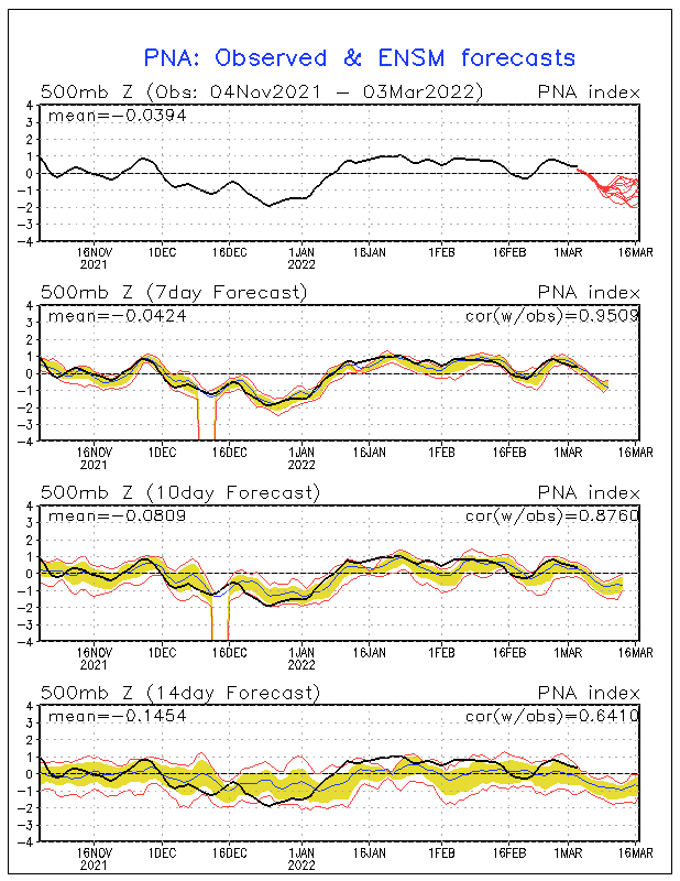
Do you consider the end of the line to still be neutral? It’s approaching -2 but I honestly don’t know if that’s significant.wetcoast91 wrote: ↑Thu Dec 03, 2020 9:35 am Model noise in the 13-15 day range but looks like the models keep the quasistationary ridge along the west coast in the believable range. You expect the colder values depicted in the mid-range to turn really mild as we edge on the southern storm track.
Neutral = active
- wetcoast91
- Storm Chaser

- Posts: 6215
- Joined: Sun Feb 17, 2019 3:12 pm
- Location: New Westminster
- Elevation: 106m
- Has thanked: 6165 times
- Been thanked: 14139 times
Re: December 2020 Forecasts and Discussions
Its always -2 to -4 towards the 13-15 day range. 5 days ago...models indicated a stark drop to -2 by Dec 10. Partly due to the poorer resolution in clown range and overdoing cold airmasses over the rockys.
- PortKells
- Storm Chaser

- Posts: 6690
- Joined: Sun Feb 17, 2019 4:08 pm
- Location: Port Kells
- Elevation: 78m
- Has thanked: 561 times
- Been thanked: 11567 times
Re: December 2020 Forecasts and Discussions
Thanks. So you think we’re waiting until January at the earliest?wetcoast91 wrote: ↑Thu Dec 03, 2020 11:01 am Its always -2 to -4 towards the 13-15 day range. 5 days ago...models indicated a stark drop to -2 by Dec 10. Partly due to the poorer resolution in clown range and overdoing cold airmasses over the rockys.
- wetcoast91
- Storm Chaser

- Posts: 6215
- Joined: Sun Feb 17, 2019 3:12 pm
- Location: New Westminster
- Elevation: 106m
- Has thanked: 6165 times
- Been thanked: 14139 times
Re: December 2020 Forecasts and Discussions
Pretty much.
Do not see a -AO and -PNA in the next 3 weeks. Storm track aimed towards us or due north with amplified ridging between wet periods. PV remains near the poles/Hudson. There is a very cold pool of air building near the poles.
SSW looks like a sure bet for late Dec. Do we see that align with a -PNA?
- Antares
- Model Rider

- Posts: 1329
- Joined: Sun Feb 17, 2019 3:10 pm
- Location: Wellington, PEI
- Elevation: 5m
- Has thanked: 1654 times
- Been thanked: 2345 times
Re: December 2020 Forecasts and Discussions
We don't need a -PNA for snowfall though...right?
It always snows in December in the Kootenays 
- AbbyJr
- Storm Chaser

- Posts: 5632
- Joined: Sun Feb 17, 2019 2:14 pm
- Location: Abbotsford
- Elevation: 50m(164ft)
- Has thanked: 10391 times
- Been thanked: 10148 times
Re: December 2020 Forecasts and Discussions
You need cold for snow and I'm not sure how you plan to get cold without at least a NW flow, which would need a -PNA in our regions.
I would say no snow without a -PNA.
Central Abbotsford
50m (164ft)
2022/23 season snowfall: 76.8cm


50m (164ft)
2022/23 season snowfall: 76.8cm


- Antares
- Model Rider

- Posts: 1329
- Joined: Sun Feb 17, 2019 3:10 pm
- Location: Wellington, PEI
- Elevation: 5m
- Has thanked: 1654 times
- Been thanked: 2345 times
Re: December 2020 Forecasts and Discussions
Well luckily, that other guy above is wrong about no -PNA showing up soon:


It always snows in December in the Kootenays 
- Antares
- Model Rider

- Posts: 1329
- Joined: Sun Feb 17, 2019 3:10 pm
- Location: Wellington, PEI
- Elevation: 5m
- Has thanked: 1654 times
- Been thanked: 2345 times
Re: December 2020 Forecasts and Discussions
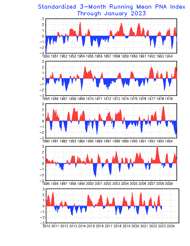
Here's an interesting graphic. December 2008 does not appear to be negative at all; it's either slightly positive or just neutral.


It always snows in December in the Kootenays 
- wetcoast91
- Storm Chaser

- Posts: 6215
- Joined: Sun Feb 17, 2019 3:12 pm
- Location: New Westminster
- Elevation: 106m
- Has thanked: 6165 times
- Been thanked: 14139 times
Re: December 2020 Forecasts and Discussions
https://www.cpc.ncep.noaa.gov/products/ ... scii.tablr
It was near +1.3 in Nov and -1.41 in Dec 2008. -1.41 may not seem impressive but that is a monthly average with what was a major +PNA to start off the month.
Major regionwide arctic blasts are tied to a -PNA. Neutral PNA can deliver some cool and wet weather but you are getting nowhere with a +PNA and +AO.
- AbbyJr
- Storm Chaser

- Posts: 5632
- Joined: Sun Feb 17, 2019 2:14 pm
- Location: Abbotsford
- Elevation: 50m(164ft)
- Has thanked: 10391 times
- Been thanked: 10148 times
Re: December 2020 Forecasts and Discussions
Looking at that graphic, parts of 2008 was a +PNA but other parts was a -PNA. December was definitely a -PNA for the duration of the cold and snowy pattern.
Central Abbotsford
50m (164ft)
2022/23 season snowfall: 76.8cm


50m (164ft)
2022/23 season snowfall: 76.8cm


- wetcoast91
- Storm Chaser

- Posts: 6215
- Joined: Sun Feb 17, 2019 3:12 pm
- Location: New Westminster
- Elevation: 106m
- Has thanked: 6165 times
- Been thanked: 14139 times
- Typeing3
- Weather Psycho

- Posts: 12741
- Joined: Sun Feb 17, 2019 3:02 pm
- Location: Coquitlam
- Elevation: 25M./80Ft.
- Has thanked: 22204 times
- Been thanked: 24584 times
Re: December 2020 Forecasts and Discussions
Need to really tank that PNA to see a classic blast with arctic air coming down the pipe from the Yukon into the interior.wetcoast91 wrote: ↑Thu Dec 03, 2020 1:24 pm https://www.cpc.ncep.noaa.gov/products/ ... scii.tablr
It was near +1.3 in Nov and -1.41 in Dec 2008. -1.41 may not seem impressive but that is a monthly average with what was a major +PNA to start off the month.
Major regionwide arctic blasts are tied to a -PNA. Neutral PNA can deliver some cool and wet weather but you are getting nowhere with a +PNA and +AO.
Too much -EPO without a low PNA value generally leads to chilly dry backdoor blasts. Those can be top tier for Oregon but nothing special for us further north.
East Coquitlam
Elevation 25M (80Ft)
#MrJanuary
- PortKells
- Storm Chaser

- Posts: 6690
- Joined: Sun Feb 17, 2019 4:08 pm
- Location: Port Kells
- Elevation: 78m
- Has thanked: 561 times
- Been thanked: 11567 times
Re: December 2020 Forecasts and Discussions
What? The snowfall charts on the weeklies are not anything close to 99/2000 and its 2 cm of snow.
